1/24
Map Pad GPS Land Surveys & Measurements screenshot 0
Map Pad GPS Land Surveys & Measurements screenshot 1
Map Pad GPS Land Surveys & Measurements screenshot 2
Map Pad GPS Land Surveys & Measurements screenshot 3
Map Pad GPS Land Surveys & Measurements screenshot 4
Map Pad GPS Land Surveys & Measurements screenshot 5
Map Pad GPS Land Surveys & Measurements screenshot 6
Map Pad GPS Land Surveys & Measurements screenshot 7
Map Pad GPS Land Surveys & Measurements screenshot 8
Map Pad GPS Land Surveys & Measurements screenshot 9
Map Pad GPS Land Surveys & Measurements screenshot 10
Map Pad GPS Land Surveys & Measurements screenshot 11
Map Pad GPS Land Surveys & Measurements screenshot 12
Map Pad GPS Land Surveys & Measurements screenshot 13
Map Pad GPS Land Surveys & Measurements screenshot 14
Map Pad GPS Land Surveys & Measurements screenshot 15
Map Pad GPS Land Surveys & Measurements screenshot 16
Map Pad GPS Land Surveys & Measurements screenshot 17
Map Pad GPS Land Surveys & Measurements screenshot 18
Map Pad GPS Land Surveys & Measurements screenshot 19
Map Pad GPS Land Surveys & Measurements screenshot 20
Map Pad GPS Land Surveys & Measurements screenshot 21
Map Pad GPS Land Surveys & Measurements screenshot 22
Map Pad GPS Land Surveys & Measurements screenshot 23
Map Pad GPS Land Surveys & Measurements Icon

Map Pad GPS Land Surveys & Measurements

Andrzej Bieniek
Trustable Ranking Iconเชื่อมั่น
2K+ดาวน์โหลด
13.5MBขนาด
Android Version Icon4.1.x+
เวอร์ชั่นแอนดรอยด์
7.5.0(19-05-2019)เวอร์ชั่นล่าสุด
5.0
(2 รีวิว)
Age ratingPEGI-3
วิธีการติดตั้ง
1
ดาวน์โหลดและเปิดไฟล์การติดตั้ง
2
Unblock AptoideAptoide is a safe app! Just tap on More details and then on Install anyway.
3
เสร็จสิ้นการติดตั้งและเปิดAptoide
app-card-icon
รายละเอียดรีวิวเวอร์ชั่นข้อมูล
1/24

คำอธิบายของ Map Pad GPS Land Surveys & Measurements

Use MapPad to calculate areas, perimeters and distances and save, export or share your measurements.


MapPad is providing multi-purpose mapping solution allowing location capture and determines distance and area for the shapes drawn on the map or captured using real-time GPS tracking.


Calculate area of the field or a walk distance instantly using Google or Bing Map Satellite view. Save petrol and time and capture features with few clicks on the map.

With MapPad you can capture, manage and share your data easily.


MapPad is a very useful tool for anyone involved in forestry, agriculture, engineering and real estate management.


Please visit our website to find out how to prepare offline map and get more information about this product.


Selected features:


- Base maps: Google Maps, Open Street Map, Bing Maps


- Google Maps Overlays (Custom WMS or ArcGIS Server Tiled service), some layers like US Topographic map have been predefined.


- Very accurate measurement of areas and distances.


- 3 methods of measurement are supported (Tap on the map, GPS location, Map cursor location).


- Support for number of metric and imperial units.


- Support for several global and local coordinate systems, if you require support for any other spatial reference please get in touch.


- Possibility to capture waypoints and group them in categories.


- Possibility to add or edit title and description for each recorded measurement and waypoint.


- Export single or multiple measurements or waypoints to SHP File, Geojson, ArcGIS Json, KML, GPX, CSV and DXF to SD Card or cloud services las well as direct export to Open Street Map.


- Share single waypoint location directly by SMS, E-mail or other ways.


- Elevation profile available for measurements done by GPS.


- Import of KML and GPX files to the application.


- GPS status and satellites status.


- Address, location search.


- Quick open exported KML files in Google Earth


- Ability to set default measurement units, waypoints' categories colours, track recording time and distance interval, transparency of Google Maps overlays and much more...


Our users are successfully using MapPad in number of projects and applications.

ใช้ MapPad เพื่อคำนวณพื้นที่ปริมณฑลและระยะทางแล้วบันทึกส่งออกหรือแชร์การวัดของคุณ


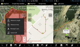
MapPad ให้บริการโซลูชั่นการทำแผนที่อเนกประสงค์ที่ช่วยให้การจับตำแหน่งและกำหนดระยะทางและพื้นที่สำหรับรูปร่างที่วาดบนแผนที่หรือบันทึกโดยใช้การติดตาม GPS แบบเรียลไทม์


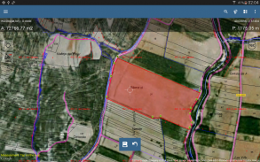
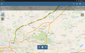
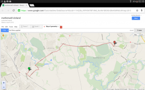
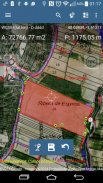
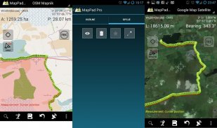
คำนวณพื้นที่ของสนามหรือระยะทางเดินทันทีโดยใช้มุมมองดาวเทียม Google หรือ Bing Map ประหยัดน้ำมันและเวลาและบันทึกฟีเจอร์ด้วยการคลิกเพียงไม่กี่ครั้งบนแผนที่

ด้วย MapPad คุณสามารถจับภาพจัดการและแบ่งปันข้อมูลของคุณได้อย่างง่ายดาย


MapPad เป็นเครื่องมือที่มีประโยชน์มากสำหรับทุกคนที่เกี่ยวข้องกับการป่าไม้การเกษตรวิศวกรรมและการจัดการอสังหาริมทรัพย์


โปรดเยี่ยมชมเว็บไซต์ของเราเพื่อดูวิธีการจัดทำแผนที่ออฟไลน์และรับข้อมูลเพิ่มเติมเกี่ยวกับผลิตภัณฑ์นี้
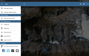

คุณสมบัติที่เลือก:


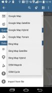
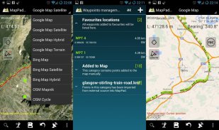
- แผนที่ฐาน: Google Maps, แผนที่ถนนเปิด, Bing Maps


- การซ้อนทับของ Google Maps (กำหนดเอง WMS หรือบริการกระเบื้องเซิร์ฟเวอร์ ArcGIS) เลเยอร์บางอย่างเช่นแผนที่ภูมิประเทศของสหรัฐอเมริกาได้ถูกกำหนดไว้แล้ว


- การวัดพื้นที่และระยะทางที่แม่นยำมาก


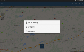
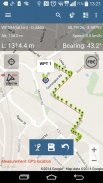
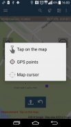
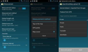
- รองรับการวัด 3 วิธี (แตะบนแผนที่, ตำแหน่ง GPS, ตำแหน่งเคอร์เซอร์แผนที่)


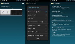
- รองรับจำนวนหน่วยเมตริกและหน่วยอิมพีเรียล


- รองรับระบบพิกัดทั่วโลกและท้องถิ่นหลายระบบหากคุณต้องการการสนับสนุนสำหรับการอ้างอิงเชิงพื้นที่อื่น ๆ โปรดติดต่อ


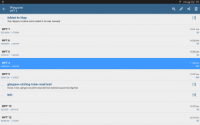
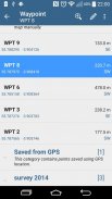
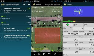
- ความเป็นไปได้ในการจับจุดและจัดกลุ่มตามหมวดหมู่


- ความเป็นไปได้ที่จะเพิ่มหรือแก้ไขชื่อและคำอธิบายสำหรับการวัดและจุดอ้างอิงแต่ละครั้ง


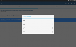
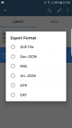
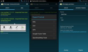
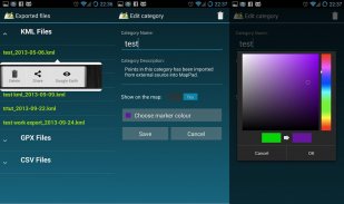
- ส่งออกการวัดเดี่ยวหรือหลายจุดหรือจุดทางไปยังไฟล์ SHP, Geojson, ArcGIS Json, KML, GPX, CSV และ DXF ไปยังการ์ด SD หรือบริการคลาวด์รวมถึงส่งออกโดยตรงไปยัง Open Street Map


- แบ่งปันตำแหน่งจุดเดียวเดียวโดยตรงทาง SMS, E-mail หรือวิธีอื่น ๆ


- โปรไฟล์ระดับความสูงพร้อมใช้งานสำหรับการวัดโดย GPS


- นำเข้าไฟล์ KML และ GPX ไปยังแอปพลิเคชัน


- สถานะ GPS และสถานะดาวเทียม


- ที่อยู่การค้นหาตำแหน่ง


- เปิดไฟล์ KML ที่ส่งออกอย่างรวดเร็วใน Google Earth


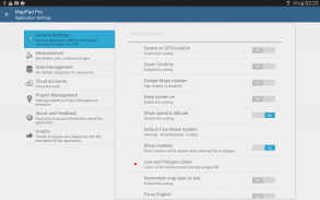
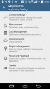
- ความสามารถในการตั้งค่าหน่วยการวัดเริ่มต้นสีหมวดหมู่ของจุดบนเส้นทางเวลาบันทึกการติดตามและช่วงระยะทางความโปร่งใสของภาพซ้อนทับของ Google Maps และอีกมากมาย ...


ผู้ใช้ของเราประสบความสำเร็จในการใช้ MapPad ในจำนวนโครงการและแอปพลิเคชัน


Map Pad GPS Land Surveys & Measurements--เวอร์ชั่น7.5.0

(19-05-2019)
เวอร์ชั่นอื่น
ข่าวใหม่FIX: The app was not working with Android 9 - now fixed.

ไม่มีการรีวิวหรือให้คะแนน! ก่อนออกโปรด

-
2 Reviews
5
4
3
2
1
Info Trust Icon
รับประกันแอปดี!แอปนี้ผ่านการทดสอบความปลอดภัยด้านไวรัส มัลแวร์ และสิ่งโจมตีอื่นๆ และไม่มีสิ่งคุกคามใดๆ

Map Pad GPS Land Surveys & Measurements - ข้อมูล APK

เวอร์ชั่น APK: 7.5.0แพ็คเกจ: com.osedok.mappad
แอนดรอยด์ที่เข้ากันได้: 4.1.x+ (Jelly Bean)
นักพัฒนา:Andrzej Bieniekนโยบายความเป็นส่วนตัว:https://sites.google.com/view/mappad-privacy-policyอนุญาต:11
ชื่อ: Map Pad GPS Land Surveys & Measurementsขนาด: 13.5 MBดาวน์โหลด: 949เวอร์ชั่น : 7.5.0วันที่ปล่อย: 2023-10-10 19:04:58หน้าจอขั้นต่ำ: SMALLCPU ที่รองรับ: x86, x86-64, armeabi, armeabi-v7a, arm64-v8a, mips, mips64
ID ของแพคเกจ: com.osedok.mappadลายเซ็น SHA1: 72:72:DE:74:E5:41:17:E4:3E:4B:0E:3E:13:9C:42:58:4A:E2:C4:1Fนักพัฒนา (CN): Andrzej Bieniekองค์กร (O): ท้องถิ่น (L): Motherwellประเทศ (C): GBรัฐ/เมือง (ST):

เวอร์ชั่นล่าสุดของMap Pad GPS Land Surveys & Measurements

7.5.0Trust Icon Versions
19/5/2019
949 ดาวน์โหลด13.5 MB ขนาด

เวอร์ชั่นอื่น

7.0.2Trust Icon Versions
16/5/2018
949 ดาวน์โหลด9.5 MB ขนาด
7.0.0Trust Icon Versions
20/12/2017
949 ดาวน์โหลด6.5 MB ขนาด
6.5.2Trust Icon Versions
25/3/2017
949 ดาวน์โหลด4 MB ขนาด
6.5.1Trust Icon Versions
17/12/2016
949 ดาวน์โหลด4 MB ขนาด
6.5.0Trust Icon Versions
16/11/2016
949 ดาวน์โหลด4 MB ขนาด
6.0.5Trust Icon Versions
16/5/2016
949 ดาวน์โหลด4 MB ขนาด
6.0.1Trust Icon Versions
8/12/2015
949 ดาวน์โหลด4 MB ขนาด
5.7.7Trust Icon Versions
5/11/2015
949 ดาวน์โหลด4 MB ขนาด

แอปในประเภทเดียวกัน

คุณอาจจะชอบ...